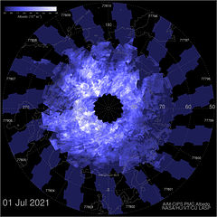
In order to capture the high northern and southern latitudes the satellite must be in a polar orbit rather than a geostationary one. Therefore, because of the Earth's rotation, each time the satellite passes over the high latitudes it will be over a different part of the Earth's surface. The imager (the Cloud Imaging & Particle Size instrument, or CIPS for short) has to look "straight down" and has a relatively small field of view, and so the swathe of atmosphere imaged in each pass is quite narrow. Moreover, because the Earth turns by more than the swathe width between each pass, when put together the swathes do not sit side-by-side but rather resemble the petals on a flower whose centre is at the pole - hence the nickname of "daisy" used for this type of image.
 | This image shows a typical daisy, constructed by AIM Mission Control by overlaying the swathes imaged during each pass in one day. The white markings clustered around the central area are the Polar Mesospheric Clouds which the CIPS instrument on the satellite is designed to detect. The central area itself, i.e. the area immediately around the North Pole in this case, is blank because as the satellite's orbit is actually "near-polar" rather than strictly polar it never flies directly over either pole. The orbit is arranged to be near polar (inclined at 98 degrees in fact) because the gravitational forces on this type of orbit, due to the fact that the Earth is not a perfect sphere, cause its plane to slowly rotate over the course of a year, which maintains its orientation with respect to the Sun. This ensures that the satellite passes over any given point on the Earth's surface at the same local time, thereby arranging that each swathe is captured under the same lighting conditions, which greatly aids the comparison of successive swathes. |
The orbital period of the satellite is 95.1 minutes and so the angle between successive swathes is in fact 23.775 degrees (as the Earth turns 15 degrees in one hour). This means that the petals are separated by a considerable distance once one goes below about 70 degrees latitude. In fact, at 50 degrees latitude the distance between successive swathes is about the same as the swathe width and so the likelihood of a given "non-polar" area being imaged at all on a particular day is only about 50/50.
Fortunately, the odds that a given area will be under a swathe at some time are improved considerably by the fact that the daisy pattern slowly rotates round the pole as the days progress. With the orbital period mentioned above, the satellite will complete 15.14 orbits per day. It will therefore complete exactly 15 orbits (and thus be at the same latitude as it was on the first orbit) in slightly less than a day. The Earth will have made slightly less than a full rotation by this time and so the area of the atmosphere under the satellite at this instant will be shifted slightly to the east relative to that on the first orbit. In consequence, the entire swathe captured during the 15th orbit will itself be shifted to the east relative to the swathe captured on the first orbit. This logic of course applies to all the swathes in the daisy and so for a daisy showing the North Pole the entire pattern will shift round anti-clockwise every day.
The amount of the shift can be easily calculated. 15 full AIM orbits will take 1426.5 minutes, but the Earth takes 1440 minutes to complete a full rotation. The satellite thus gets into position 13.5 minutes "early". At this instant the Earth still has another 3.375 degrees to go before it too has returned to its previous position; this is therefore the amount each swathe, and therefore the daisy, shifts each day. It follows from this that the petals of the daisy will repeat their angular positions every 7 days (the separation angle of 23.775 degres divided by the daily shift of 3.375 degrees), which means that at "non-polar" latitudes a given area of the surface will be imaged to exactly the same extent only at this interval. If you click or tap on the image above it will cycle through the daisies captured on the seven days afterwards. You will see that a) the pattern of "petals" rotates anti-clockwise, and b) the orientation of the petals on the eighth day is very nearly the same as on the first - click/tap again to show the initial daisy to check this (and once more to re-run the animation).
It must be noted though that even if an area is indeed imaged this will only happen during just one pass on that day, and of course this pass might be at the wrong time of day to capture any atmospheric activity. There are two reasons why the timing might be wrong. Firstly, AIM can only capture data relating to NLCs when the area it is looking at is in daylight. This immediately rules out seeing any NLCs at the exact time they are observed, as this will always be in the hours of darkness. Secondly, although the clouds do often exist before they become illuminated by the setting Sun and also often persist into the daylight hours (although of course they cannot then be observed), for them to be seen by AIM under these conditions the orbit which images the UK must be timed for the early evening or the early morning. If not, the clouds might well have dispersed by the time AIM passes over.
All in all, therefore, the chance of striking lucky and seeing the NLCs observed from the ground in an AIM daisy is pretty slim!